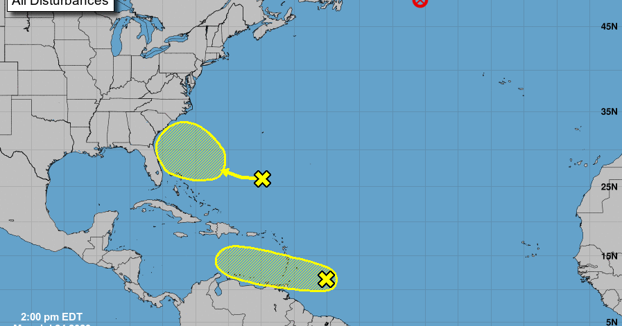
A new tropical disturbance a few hundred miles south of Bermuda was detected Monday afternoon by the National Hurricane Center, making it the second currently in the Atlantic.
The first disturbance is west of the Windward Islands. Those two are in addition to Don, now a post-tropical cyclone in the northern Atlantic which became the fifth longest-tracked tropical system in July.
The new system is an area of low pressure but is still too weak to become a cyclone in the next couple of days. There's a low chance it becomes a tropical cyclone in the next week as it moves towards the southeastern U.S. coast.
The system east of the Windward Islands is still kicking, and still has a low chance of becoming a tropical cyclone in the next two-to-seven days.
This disturbance was first noticed by the NHC last Wednesday. In an afternoon update, forecasters said the system hasn't become much more organized than before, but that development is still possible as it moves towards the Caribbean Sea.
Even if tropical cyclone development doesn't happen, the Lesser Antilles are still in for heavy rains and gusty winds as the system passes through over the next two days. If the system doesn't develop soon, then chances for it to strengthen will decrease since conditions for development will deteriorate by the middle of this week. This is due to Saharan dust and other factors.
Don is officially a post-tropical cyclone, according to a morning update from the NHC. The cyclone has winds of 45 mph and is moving at 20 mph, and is expected to continue losing strength as it coasts over cooler waters. Don should continue to weaken and is expected to dissipate as early as Tuesday.
Don first became a disturbance on July 10, near Bermuda. It briefly became the season's first hurricane over the weekend, but quickly lost power as it moved over cooler waters. Because forecasters have been tracking the cyclone for two weeks, Don is now the fifth-longest July tropical cyclone, with the next-longest being Hurricane Emily in 2005. It did not make landfall anywhere.
The 2023 hurricane season
The return of El Niño could bring a wetter second half of the year to Louisiana and a reduced risk of hurricanes.
The National Oceanic and Atmospheric Association's Climate Prediction Center announced March 9 that La Niña, which usually causes more hurricanes to form in the Atlantic, was officially over after an unusually long three years.
El Niño and its sister La Niña are part of the El Niño-Southern Oscillation cycle, a set of conditions over the Pacific Ocean that affects weather patterns across the world. In Louisiana, the biggest effects involve hurricane season in the Atlantic Ocean.
Regardless, this year's first cyclone formed in January, long before the official start of hurricane season, and June alone saw three named storms. Now forecasters are predicting that 2023 will prove to be an above-average hurricane season, with 18 named storms.
The first tropical storm to form in the Atlantic this year was named Arlene, reaching wind speeds of 40 mph on June 2 as it headed for Cuba. Don was the first storm to reach hurricane status in 2023, producing maximum sustained wind speeds of 75 mph on July 22 before rapidly weakening to a tropical storm the following day.
Bagikan Berita Ini


0 Response to "New tropical disturbance spotted south of Bermuda, may be headed to the US - NOLA.com"
Post a Comment